

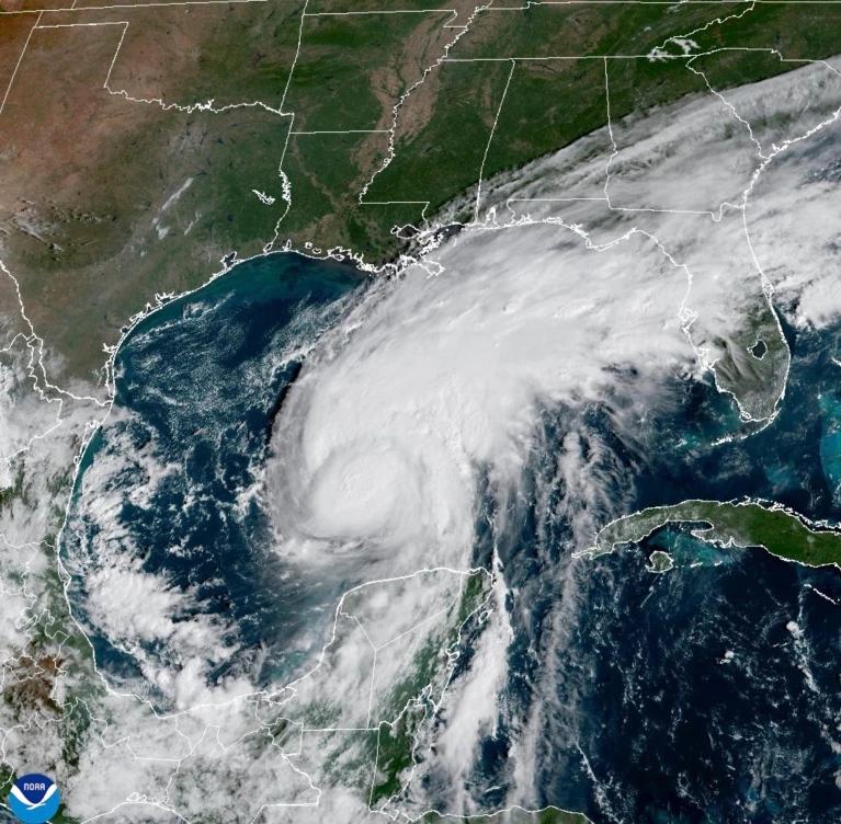
Hurricane Isaias is developing in an unusual battle between two powerful forces: strong winds linked to El Niño and warm water in the Gulf of Mexico. The storm has strengthened despite weather conditions that often make Atlantic hurricanes weaker. Forecasters are now watching how those forces will affect its path and intensity as it moves toward the coast of the southern United States.
El Niño is a natural climate pattern that warms parts of the tropical Pacific Ocean. It can change weather across the world, including the strength and direction of winds over the Atlantic. During many El Niño periods, stronger winds high above the ocean disrupt developing storms. This process, known as wind shear, can tilt a storm and stop it from forming the organized structure needed to become stronger.
Isaias has faced these unfavorable winds, but the Gulf of Mexico has also been unusually warm. Water temperatures have been about 2.7 degrees Fahrenheit above normal in some areas, giving the storm extra heat and moisture. Warm water helps hurricanes draw energy from the ocean. When wind shear temporarily weakens, a storm can take advantage of that energy and intensify quickly.
Scientists say the storm reflects a wider challenge in forecasting hurricanes during unusual climate conditions. Several factors can influence a storm at the same time, and their effects may change within hours. Forecasters must track wind patterns, ocean temperatures, air pressure and the storm’s internal structure to estimate how strong it may become before landfall.
Isaias is expected to approach the coast between Mississippi, Alabama and Florida. The exact location and strength at landfall remain important because they will affect the areas most exposed to storm surge, heavy rain and damaging winds. Even if the storm weakens before reaching land, flooding can remain dangerous. Water pushed inland by the storm can cover roads, damage homes and threaten people living in low-lying areas.
Climate change adds another layer of risk. Warmer air can hold more moisture, which may increase the amount of rain a storm produces. Rising sea levels can also make storm surge more damaging because the water starts from a higher baseline. These changes do not mean every storm will become stronger, but they can increase the danger posed by storms that bring heavy rain or push seawater onto land.
The storm has also drawn attention because the Atlantic hurricane season has been unusually quiet in some respects. Strong wind patterns linked to El Niño have limited the growth of many systems. Isaias, however, found a period when conditions allowed it to strengthen. The contrast shows why seasonal patterns cannot predict every storm’s behavior and why local conditions remain important.
Emergency officials are urging people in vulnerable areas to follow local instructions and prepare for possible flooding. Residents may need to secure outdoor items, charge devices, gather supplies and avoid driving through floodwater. Roads can become dangerous quickly when rain falls faster than drainage systems can handle it. People should rely on official forecasts rather than assumptions based on the storm’s current category.
Hurricane Isaias is a reminder that weather risks are shaped by both natural patterns and a warming climate. El Niño winds may weaken the storm, while warm Gulf waters can help it grow. The final outcome will depend on how those forces change before landfall. For communities along the coast, the most important issue is not only how strong the storm becomes, but also how much water and wind it brings when it arrives.
